
Beneath the Sunlit Stones of Puerto Lumbreras
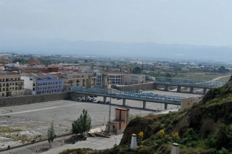
On a hot day in Puerto Lumbreras, the Rambla de Nogalte can appear almost motionless. Pebbles lie exposed beneath a wide, pale sky, and the channel seems less like a river than a rough corridor of stone crossing the town. Yet beneath that apparently dry surface, water once moved through a carefully shaped underground system. The contrast is central to understanding the municipality: an austere landscape above, and a hidden, life-giving flow below.
Puerto Lumbreras developed on the frontier between mountain country and the agricultural plains of southeastern Murcia, where rainfall is limited but cloudbursts can be sudden and destructive. In this semi-arid setting, settlement depended on capturing water when it appeared, protecting it from evaporation, and sharing it in a dependable way. The result was not a single monumental dam, but a network of practical structures integrated into the landscape and daily life.
At its heart were the caño and contracaño, filtration galleries built beneath the rambla. Together, they transformed seasonal runoff and shallow underground water into a controlled supply for fountains, washhouses, mills, cisterns, and irrigation channels. The system shows how vernacular engineering could turn a hydrological threat into communal prosperity. Preserving this historical hydrological heritage mirrors the careful dedication seen in modern conservation programs, where old structures are treated as practical records of environmental knowledge.
Understanding the Ephemeral Pulse of Rambla de Nogalte
The Rambla de Nogalte belongs to a broader family of non-perennial waterways. Unlike rivers that maintain surface flow throughout the year, these channels alternate between flowing, disconnected, and completely dry phases. Their gravel beds may carry torrents after a storm, then remain apparently empty for months. The scientific literature on non-perennial river networks, including this study of intermittent channels, emphasizes that dry riverbeds are not hydrologically empty. Water can remain stored in sediment, move beneath the surface, or reappear in short pulses after rainfall.
For communities along Mediterranean rambla systems, that irregular rhythm created two opposing problems. A cloudburst could send a fast, sediment-heavy flood through the channel, while the long dry season offered little or no reliable surface water. Conventional open reservoirs were vulnerable to evaporation, contamination, and damage from flood surges. Subsurface collection therefore made practical sense because it worked with the character of the terrain rather than trying to impose a permanent river on it.
- Gravel and sand layers could retain water after visible flow had disappeared.
- Underground galleries reduced exposure to intense solar heat and evaporation.
- Buried channels offered protection from debris, animals, and accidental contamination.
- Gravity allowed water to travel toward lower settlements without continuous mechanical pumping.
The Anatomy of Subterranean Engineering
The caño functioned as the primary collecting conduit. Set within the alluvial material of the rambla, it intercepted water moving through sand and gravel after rainfall or flood events. Rather than taking the full force of a surface torrent, the gallery gathered the slower, filtered movement beneath it. The contracaño worked as a complementary or counter-drainage gallery, helping manage the underground flow and extend the area from which water could be captured. Together, the two structures formed a qanat-like system adapted to local geology and the particular behavior of the Rambla de Nogalte.
The filtration process was simple in principle but effective in practice. As water passed through layers of gravel and sand, larger sediment was held back and the flow became clearer. Covering the galleries reduced direct evaporation, while the surrounding material helped shield the supply from many surface pollutants. This did not make the water automatically safe by modern drinking-water standards, but it created a naturally moderated source suitable for historical domestic, agricultural, and industrial uses. The arrangement also delayed the movement of water, allowing storage within the ground rather than forcing every drop into an exposed basin.
| Component | Primary role | Connection to community life |
|---|---|---|
| Caño | Collected filtered subsurface water beneath the rambla | Fed fountains, reservoirs, washhouses, and distribution channels |
| Contracaño | Supported counter-drainage and regulation of underground flow | Helped stabilize the supply and protect the gallery network |
| Balsa de los Caños | Stored collected water before further use | Provided a point for managed distribution |
| Canals and dividing structures | Directed water toward mills and agricultural plots | Connected hydraulic infrastructure with the huerta |
The wider network extended beyond the galleries. Water moved by gravity toward the Los Caños fountain, the reservoir, and the washhouse, then onward through channels and dividing structures. The official description of the Ruta del Agua helps visitors understand this sequence as a connected landscape rather than a collection of isolated monuments. Every element had a role, from underground capture to storage, distribution, and reuse.
Everyday Life Sustained by the Hidden Streams
The value of the caño and contracaño was measured in ordinary routines. Water supplied public washhouses, where household work could be carried out in a shared setting, and powered flour mills associated with the rambla. The historic mills at Jerez and Arcos illustrate how water management supported local processing and trade. A channel was therefore not merely a technical feature. It linked farming, food production, domestic labor, and the movement of people through the town.
Rural estates and traditional homesteads also depended on the same logic of capture and storage. Casa del Cura, an eighteenth-century manor house with a rural cortijo form, included agricultural land, gardens, an annex for workers, and a substantial cistern beneath a brick barrel vault. Its later association with water management in the Rambla de Nogalte, including the Balsa de la Sociedad de Aguas, shows how private estates were tied to wider communal systems. Water reached fields and orchards, but its use was shaped by rules intended to protect the collective supply.
- Fountains provided accessible points for collecting water.
- Washhouses supported communal domestic work and hygiene.
- Mills converted hydraulic energy into flour-processing capacity.
- Cisterns protected stored water for homes, livestock, and gardens.
- Distribution channels carried measured flows toward plots in the huerta.
Equity required more than construction. Communities had to decide who received water, when channels were opened, and how maintenance was organized. Such arrangements limited waste and reduced conflict during dry periods. The historic huerta was sustained by a combination of physical infrastructure and social agreements, a reminder that water security depends as much on governance and shared responsibility as on engineering.
Walking the Living Heritage Trail
The approximately three-kilometre Ruta del Agua offers a compact way to read Puerto Lumbreras through its hydraulic history. The route begins near the viewpoint of Nogalte Castle, where the elevated position helps visitors understand the relationship between the settlement, the rambla, and the surrounding landscape. From there, views extend toward the Rambla de Nogalte and the Lumbreras, while interpretive points reveal how water was captured below ground and directed toward the town.
One of the route”s most distinctive stops is the themed Water Cave museum, installed within traditional cave dwellings. These spaces provide a useful contrast with the galleries beneath the rambla. The caves show how people adapted their homes to the local geology and climate, using thick earth-covered walls to moderate interior temperatures. Together, the cave museum and the underground waterworks present a coherent story of life below the intense Mediterranean sun.
- Begin at the Nogalte Castle viewpoint and take time to identify the rambla, settlement, and surrounding agricultural areas.
- Continue toward the Water Cave museum to explore the domestic side of local adaptation and heritage.
- Descend by the Cuesta de la Pava, cross the rambla, and follow the route toward the mills, canals, and water-dividing structures.
- Look for the Balsa de los Caños, the nearby washhouses, and the Fuente del Caño in the urban section.
- Return along the marked route or connect with paths beside the Rambla de Nogalte where conditions allow.
The walk is described as easy and suitable for visitors who want a manageable introduction to the municipality”s heritage. Even so, practical preparation matters. Summers are intensely warm, so early morning or late afternoon is more comfortable, with water, sun protection, and sturdy footwear recommended. After heavy rain, avoid entering the rambla or crossing channels until conditions are clearly safe. Autumn and spring often offer the best balance of mild temperatures, visible agricultural activity, and clear views.
Respect for the site is part of the experience. Stay on established paths, do not climb fragile hydraulic structures, and avoid removing stones or other material from the rambla. The route passes through living urban and agricultural spaces, so keep noise low near homes and leave gates, channels, and farm boundaries undisturbed. Visitors with limited mobility should check current local conditions before setting out, as historic surfaces, slopes, and crossings may not offer uniform accessibility.
Rediscover Arid Ingenuity in Modern Landscape Design
The caño and contracaño speak directly to current questions about water in dry regions. Their central principles remain relevant: slow water down, allow sediment to filter it, store it close to where it will be used, limit evaporation, and connect technical infrastructure with community rules. These principles can inform modern approaches such as groundwater recharge, shaded storage, flood-sensitive public spaces, permeable surfaces, and landscape designs that accept occasional flooding rather than treating every storm as an enemy.
Historic infrastructure should not be copied uncritically, and modern drinking-water standards require safeguards that earlier communities did not possess. Nevertheless, the system offers a valuable lesson in climate-conscious design. Puerto Lumbreras did not wait for a constant river. It learned to work with an intermittent one, using local materials, gravity, accumulated observation, and collective management. To explore that achievement, walk the Ruta del Agua, visit the Water Cave museum, and follow the line from the castle viewpoint down toward the rambla. Beneath the sunlit stones, the landscape still explains how careful stewardship can make scarcity support a community.